Uncovering the Secrets and Vulnerability of Glastonbury Lake Village
 Richard Brunning
Researching and protecting England’s best-preserved Iron Age settlement.
This project was the first investigation of the heart of this iconic site since 1907 and allowed a new understanding of its date and character and the prospects for its preservation. It was commissioned by Historic England from South West Heritage Trust.
The Lake Village
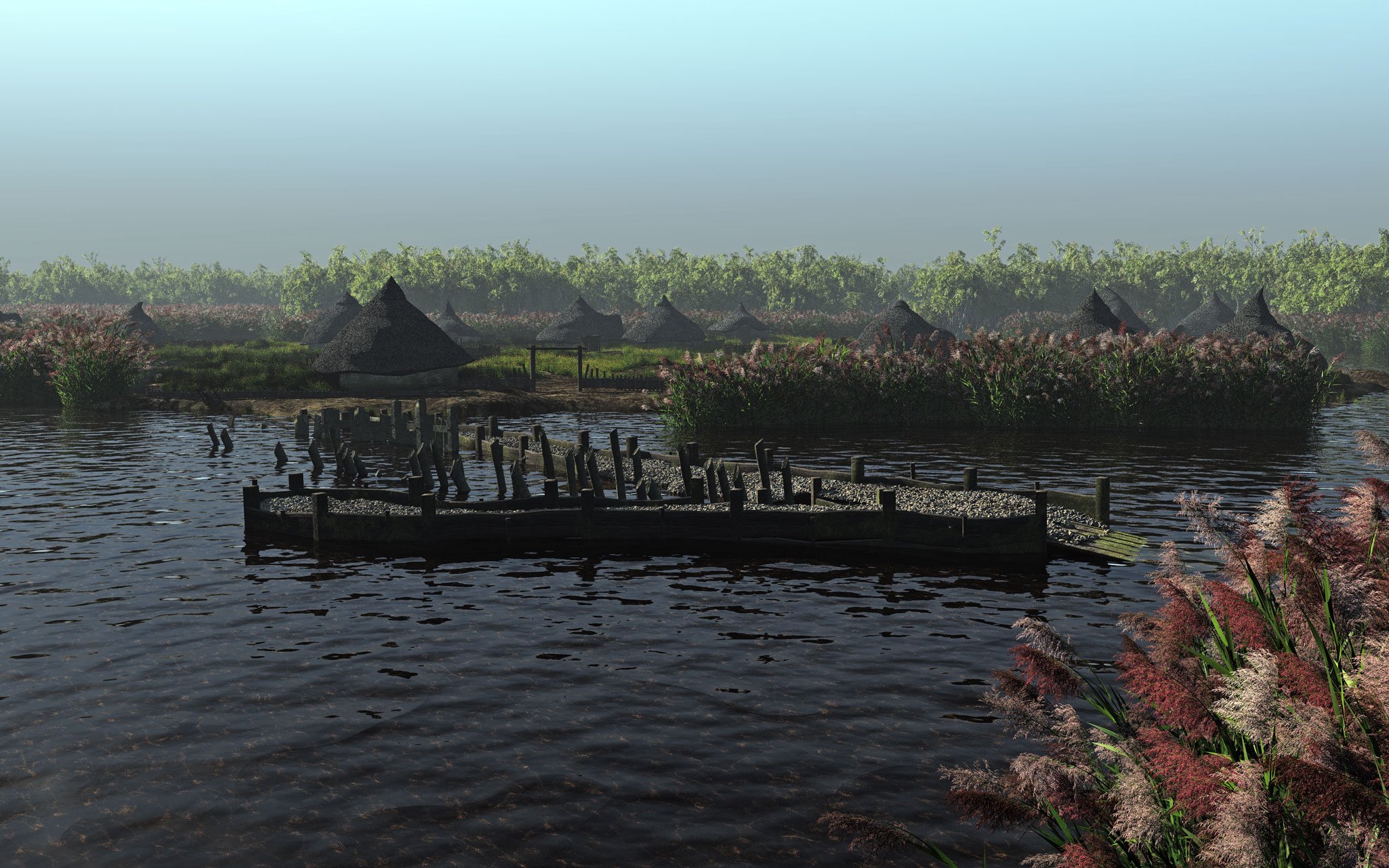
Glastonbury Lake Village is an Iron Age settlement located in the floodplain of the River Brue in Somerset. It was discovered in 1892 by a local antiquarian, Arthur Bulleid, who, inspired by reports of the wetland villages found in alpine lakes, sought their equivalent in Somerset. The site which he found had been preserved in waterlogged peat and clay for two millennia, making it the best-preserved Iron Age settlement that has ever been discovered in the UK.

Excavations between 1892 and 1907 revealed that the Iron Age inhabitants had brought in over 1,000 tons of clay to create 90 dry mounds in the swamp, upon at least 40 of which roundhouses were created. The houses and floors were frequently rebuilt, forming occupation deposits over a metre thick, containing a fantastic array of everyday material culture, crucially including wooden items such as bowls, boxes, baskets, wheels, ladders, tool handles and complex pieces of joinery that almost never survive on archaeological sites.
Excavation is destruction
Bulleid and his co-director, Harold St George Gray, excavated the entire settlement, including each habitation mound. They left a collapsed palisade and some wall posts in situ. Later small-scale fieldwork, in 1969, 1988 and 2003, only examined the periphery of the site, at the edge of the previously excavated area (see site plan), leaving open the question of exactly how much in situ evidence had survived the early excavations in the central area. It was also known that Bulleid and Gray had reburied some of the worked timbers on the site, but no one knew if they had survived this long-term reburial experiment. Previous hydrological monitoring - that is to say, checking the variations in the water table - had suggested a potential threat to the preservation of the site due to desiccation, but to gauge the extent of that threat it was necessary to know the exact height of the surviving in situ wooden remains in relation to the water table.
Previous hydrological monitoring - that is to say, checking the level and movement of water - had suggested a potential threat to the preservation of the site due to desiccation, but to gauge the extent of that threat it was necessary to know the exact height of the surviving in situ wooden remains in relation to the water table.
Expanding knowledge
Alongside these questions of preservation, there remained uncertainty over the date and duration of the site, with some conflict between the available information from radiocarbon dating and artefact typologies. The project aimed to address the research and preservation questions through keyhole excavations in five locations, including three habitation mounds, part of the palisade surrounding the settlement and the probable site of the reburied wood.
What was left behind?
The first surprise was the quantity of material left in the backfill of the original excavations.
Although it was removed rapidly by spade in the recent fieldwork, the large number of artefacts recovered, if extrapolated across the site, suggest that this previously-excavated material could contain 6,900 sherds of pottery, 3,500 fragments of daub and 16,000 pieces of animal bone.
In the areas of the habitation mounds, the sequence of successive clay floors and hearths had been almost completely removed, usually leaving only the wooden foundations beneath.
What happens in a roundhouse?
In one trench a small patch of an early roundhouse floor surface survived in situ. Micromorphological analysis – the microscopic study of the deposits - detected layering that was not visible to the naked eye, consisting of two trampled floor surfaces, followed by the renewal of the floor using clay from a nearby freshwater source (the analysis revealed traces of freshwater algae). A mix of peat taken from elsewhere and redeposited in the roundhouse with charred elements and herbivore dung overlaid that and was in turn covered by a dense layer of woodchips.
This complex sequence of activity can be interpreted as probably taking place within a few weeks or months, providing an exciting glimpse into the life of a roundhouse that can only be revealed on sites with such exceptional preservation.
This shows short, discrete bursts of activity in addition to the periodic renewal of walls and floors every decade or so.
Samples from between two roundhouse mounds revealed pottery and bone fragments, wood, daub, charcoal and significant quantities of burnt grain of spelt wheat, barley and oats. This shows the mixture of everyday detritus that accumulated across the settlement, even though large midden deposits found at the edges of the settlement showed that most ‘rubbish’ had been dumped into the surrounding wetland. This new evidence using modern sampling adds to our knowledge- the early excavations did not record much about activity between the habitation mounds.
Not a house for life
In one trench the original excavations had removed all trace of the roundhouse that was there. In another the first wooden foundation as well as the posts that formed the walls had been left intact. The posts were surprisingly small, formed from young poplar or willow roundwood of 15-54 millimetres diameter, and were spaced 20-25 centimetres apart, with traces of wattlework woven between them.
In another area, where the previous excavations had revealed a sequence of nine successive roundhouse floors and walls, only some of the wall lines survived, again formed of small roundwood. It was possible to work out which posts related to the successive phases of rebuilding. This meant that Bayesian statistics (a method combining scientific dating and stratigraphy by probability theory) could use the knowledge of those relationships to narrow down the dating results. A sequence of eight successive palisades at the edge of the settlement allowed a similar statistical exercise..
The scientific dating results, from 67 new radiocarbon measurements, showed that the settlement was first occupied in 190–160 cal BC (68% probability) and the last constructional event probably took place in 75–45 cal BC (68% probability). It was therefore in use for a minimum of 75–135 years (95% probability).
As some habitation mounds had nine successive roundhouses on them, this suggest that the life span of the buildings was only about a decade, not surprising when such slender posts were used in their construction.
What does the future hold?
As part of the project, new water control structures were installed by the Somerset Drainage Boards on one side of the site, helping to retain water in the summer months. The fieldwork provided information on the height of the in situ undisturbed archaeology and this was compared to water table monitoring data. Most of the remains were so far below ground that they were safe from desiccation in normal summers, but the wood that had been excavated and then reburied by Bulleid was slightly higher and therefore more at risk from desiccation.
The future climate change predictions for South West England include more occasional extremes of hotter drier summers, as we have already experienced in 2022. This means that the survival of this unique site, our clearest window onto Iron Age life, will be increasingly at risk over the coming decades.

-
Marshall, P, Brunning, R, Minnitt, S, Bronk Ramsey, C, Dunbar, E. and Reimer, P.J. 2020. The Chronology of Glastonbury Lake Village.
Antiquity, 94, Issue 378, pp. 1464 - 1481.
-
Hill, TCB, Hill, GE, Brunning, R, Banerjea, RY, Fyfe, RM, Hogg, AG, Jones, J, Perez, M and Smith, DN. 2018. Glastonbury Lake Village Revisited.
A Multi-proxy Palaeoenvironmental Investigation of an Iron Age Wetland Settlement, Journal of Wetland Archaeology, 18, 115-137.
-
Brunning, R. 2022. Preserving and dating Glastonbury Lake Village, Somerset.
Historic England Research Report 4-2022.
-
Glastonbury Lake Village Recreated
A digital model of the Avalon Marshes allows this journey to the Iron Age settlement known as Glastonbury Lake Village to be recreated.
-
South West Heritage Trust Video of Excavations at Glastonbury Lake Village
The film documents a research excavation carried out at Glastonbury Lake Village in 2014.


