London Archaeology and Characterisation
 Sandy Kidd
Challenges of complex townscapes and time-depth.
The City of London with Westminster and Southwark have been at the centre of English population, government and commerce for almost 2,000 years. Occupying a gateway into the British Isles, what is now inner London has successively been the capital of Roman Britannia, an Anglo-Saxon trading emporium, the principal town of the Kingdom of England, an imperial capital and a world city.
The Great Fire of 1666 kicked off expansion into the open countryside which has carried on for over 300 years only partially constrained by modern green belt policy. London’s influence on land use has always extended well beyond its built-up area encompassing such things as transport links, mineral extraction, power and water infrastructure and places of recreation and burial.
Despite notable episodes of destruction, many historic buildings and places survive above ground, and below them the intensive occupation of inner London has created a great build-up of urban archaeological deposits of international significance.
London is an ‘Alpha World City’ with an exceptional combination of great urban time-depth, high heritage significance and demand for major development.
These pressures manifest themselves in a myriad of ways: tall buildings and ‘densification’ of leafy suburbs change the character and appearance of historic places; deep basements and underground infrastructure threaten the archaeological resource; and even the green belt is impacted by mineral extraction and transport routes.
Over the past thirty years Historic England and its predecessor English Heritage have sponsored projects to encourage better recognition of historic character in strategic planning. ‘Historic Landscape Characterisation’ (HLC) has covered rural areas whilst in larger towns urban archaeological databases or ‘Metro-Historic Landscape Characterisation’ were supported. Until recently, Greater London largely stood aside from these national initiatives, either because they were not considered suitable or due to governance, financial and logistical challenges.

New Initiatives
The adoption of the Mayor’s new London Plan in 2021 placed greater emphasis on understanding local character, recognising it in new design, and securing greater public benefit from the positive management of all heritage assets, including archaeology the focus of this article.
Two related initiatives are currently underway that seek to enhance the Greater London Historic Environment Record by building upon exploratory work carried out intermittently over the last two decades. These are London Historic Characterisation and the London Urban Archaeological Database.
London Historic Characterisation
A classification framework for London Historic Characterisation has recently been set out in a thesaurus prepared for Historic England by Land Use Consultants. It follows the well-established approach of ascribing areas of townscape (or landscape) with a common developmental history to a hierarchy of ‘character types’ based on ‘current character’ with more limited recording of ‘previous character’.
A similar approach (known as ‘London Rapid Historic Landscape Characterisation’) was tried by English Heritage around 2006 and is now being refreshed by Land Use Consultants to provide a London-wide overview that can be refined by local studies within a consistent framework. A quirk of the Rapid Historic Landscape Characterisation was that much of central London was left blank in recognition that broad-brush characterisation suitable for the urban fringe, suburbia and industrial areas would not be appropriate to the complexity and fine grain of London’s historic core.
London Urban Archaeological Database
The London Urban Archaeological Database encompasses the 17th-century built-up area and its immediate environs that were encircled by fortifications during the English Civil War. It therefore has to address the challenges of characterising all periods drawing on a wide range of evidence including built form, human and natural geography, buried archaeology and documentary evidence.
Essentially the methodology involves creating a series of ‘models’ of London’s evolution from prehistory to the present day, and the nature of surviving remains of archaeological interest.
In central London the intensity of historic land use is such that one can start with a presumption that something of archaeological interest will probably be present on a site unless removed by modern disturbance. This approach builds on the legacy of “The Future of London’s Past”, a seminal publication of 50 years ago that included a set of overlay maps: essentially a Geographical Information System on paper (Biddle and Hudson, 1973).
The London Urban Archaeological Database is a programme of related projects commissioned independently that follow a common methodology. So far these building blocks comprise:
- A pilot study (stage 1) completed by Museum of London Archaeology (MOLA) in 2013.
- Stage 2 completed by MOLA in 2017, which mapped archaeological investigations conducted up to 31 March 2013.
- Stage 3a completed by Essex Place Service (EPS) in 2021, which focussed on the medieval core of Westminster and Whitehall, mapping survival and character in time depth.
- Further stages (3b and on) are planned.
- Work by archaeological consultants Mills Whipp, who are clarifying the location, form and survival of the Civil War defences.
- Several other projects outside the London Urban Archaeological Database area which have used or contributed to methodological development.
After mapping archaeological interventions, the next step was to adapt existing methodologies to enable deep time-depth characterisation consistent with the London Historic Characterisation Thesaurus. This approach also drew inspiration from “Complex City”, a study of urban character and design: published by Allies & Morrison with support from Historic England (Manning, J. et al 2020).
Unlike conventional Historic Landscape Characterisation, the London Urban Archaeological Database has adopted a ‘time-slice’ methodology consisting of six ‘layers’ drawn from those recognised by Allies & Morrison as defining the city’s long-term development, and then further sub-divided into 21 epochs (Fig 3). These epochs cover the pre-urban landscape (2), phases of urban construction (14) and incidents of widespread urban destruction (4). In practice this means each time-slice ‘layer’ has a GIS layer constructed using the thesaurus within which there are ‘previous types’ covering epochs before the primary one. Thus, the standard single Historic Landscape Character layer approach was expanded to six.
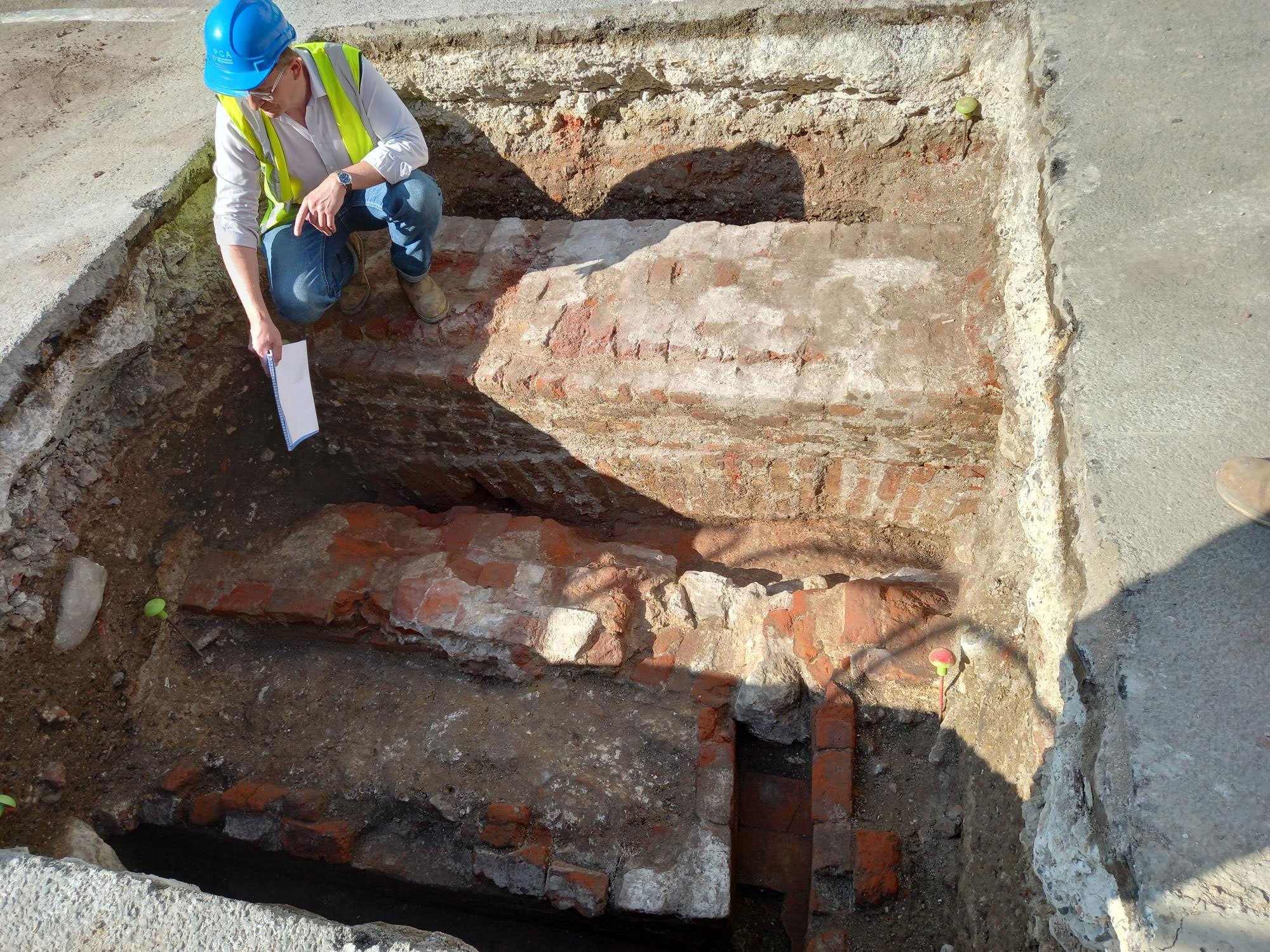
Recording of archaeological survival and potential is rather piecemeal and unsystematic in modern archaeological practice. To remedy this, the London Urban Archaeological Database has tried a characterisation-like total coverage approach. Using a series of ‘types’ it distinguishes ‘upstanding archaeology’ (buildings, ruins and earthworks) and known below-ground remains from areas of varying potential reflecting likely disturbance from modern land use. For example, walls are known to survive beneath road surfaces (see below).
Where deposits are expected to be deep, shallow basements would still be recorded as having potential. Potential for survival of waterlogged remains is assessed from previous interventions and consideration of topography and geology (Fig 6). Some pragmatic decisions have to be made such as excluding Pleistocene deposits and 18th century and later buildings.
Mapping significance is probably the most challenging and controversial aspect of this type of study and one that we have yet to fully master for non-designated assets.
Nevertheless recent casework has shown that systematic recording of planning-related judgments for major assets such as the city wall, Roman forum or monastic houses would help ensure consistent positions are adopted based on the significance of high-profile assets that normally extend beyond a single planning application boundary. In Westminster and Whitehall we explored character areas based on historical development patterns rated for presence, condition, significance and vulnerability.
In conclusion, the principles of sensitivity mapping can be applied to the finer grain of historic urban areas but methodologies need to be adapted to take account of time-depth and change.
Understanding deep time-depth character can challenge popular perceptions of ‘heritage’ as an almost ‘time-less’ inheritance. It shows that change is part of urban character and suggest ways people and places can draw inspiration not just from what is around a site but what came before, or lies beneath.
Acknowledgements
The author would like to thank the Wood consultancy and Heathrow Airports Ltd for sharing their methodology for characterising archaeological survival.

Further information
Globalization and World Cities Research Network
Historic England London Urban Archaeological database Project webpage
Historic England Historic Characterisation pages
London's Historic Character Thesaurus and User Guide 2012
Biddle, M. and Hudson, D. 1973: The Future of London's Past: A Survey of the Archaeological Implications of Planning and Development in the Nation's Capital. Rescue.
Manning J. et al 2020: Complex City: London’s Changing Character. RIBA.
Download in PDF Format
You can download this article along with the others in this issue as a PDF magazine.


