Mapping and Modelling the Historic Landscape
 Jonathan Last
Historic England Landscape Strategy Advisor Jonathan Last gives an overview to the theme of this issue: managing change at landscape level.
What do we mean by 'landscape'?
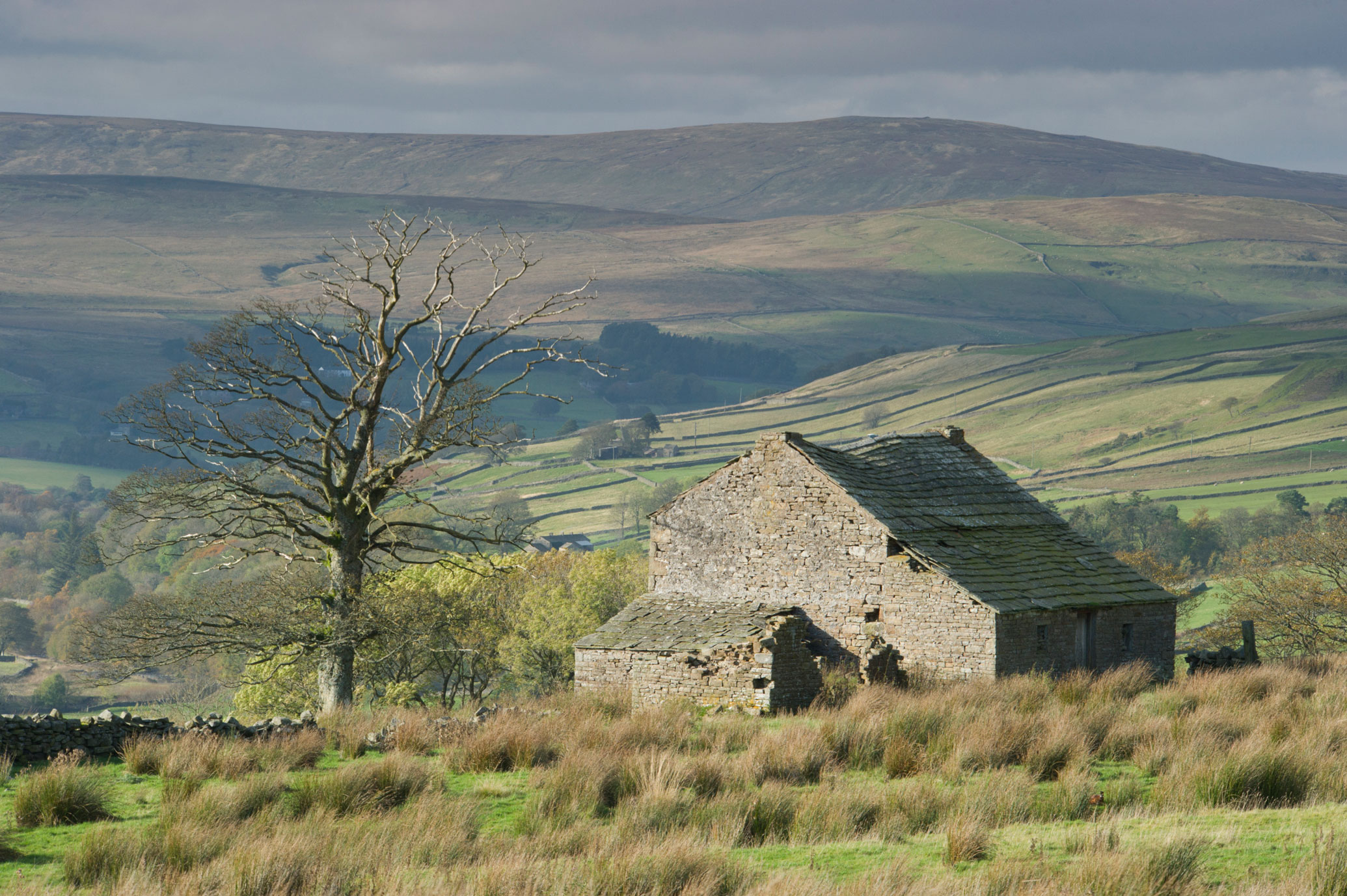
When you think of the English landscape, what comes to mind? Rolling hills, perhaps, mature woodland, or a vista of hedges and fields – in any case, something to do with nature?
Landscapes are the context in which we perceive the natural environment: habitats, wildlife and vegetation. But what can be less obvious is that they are always also historical and archaeological.

All our landscapes – upland and lowland, woodland and grassland, moor and heath – owe their character, and the ‘nature’ they contain, to millennia of human activity. One of the key policy documents for landscape, the European Landscape Convention, recognises this entanglement of the cultural and natural in its basic definition: 'landscape' means an area, as perceived by people, whose character is the result of the action and interaction of natural and/or human factors’.
The heritage sector usually has good processes and protocols for managing individual ‘assets’ – buildings, sites and monuments. But what about the wider landscape – rural, urban or industrial – with this complex historic character and often unknown, yet to some extent predictable, archaeological potential?
A key archaeological response to the related European Landscape Convention idea that ‘all landscapes matter’ was the concept of characterisation: a seamless mapping of the continuous historic character of the landscape (or seascape) designed to emphasise that the historic environment is everywhere. However its main product, Historic Landscape Characterisation (often shortened in the literature to HLC) is generally confined to the visible landscape and does not include buried archaeology.
Why working at landscape level matters
But why does it matter that we should work on a landscape level? A key aspect of landscape in this regard, including its historical and archaeological components, is that it is always changing.
Indeed, the pace of change in England’s landscapes in the decades ahead is only likely to increase, in relation to a variety of drivers including climate change impacts, requirements for new housing and infrastructure, and targets for forestry and nature recovery.
While we may seek to preserve individual sites and buildings, when it comes to the landscape the emphasis is on informed decision-making in response to inevitable change. That difference in approach requires us to understand at a broad scale, as far as possible, the sensitivity of the historic landscape (and seascape) to planned or unplanned change, and its capacity to accommodate such change.
The projects in this issue
This issue of Historic England Research rounds up a variety of current approaches to improving strategic decision-making in the face of future landscape change through the development of methods, tools and resources for better understanding of archaeological and historical sensitivity, capacity and potential at a landscape level. Characterisation in some form is often the starting point but the contributions take the idea in a variety of directions.
A particular focus of the issue is on archaeological remains of different kinds, including both visible features that still serve a purpose in the landscape and those that are buried and hidden. In either case archaeology both informs our collective understanding of the places where we live today and helps us understand trajectories of past changes in environment, climate and society. In contributing to narratives that promote resilience archaeology can therefore help us imagine and plan sustainable future landscapes.
The scale, ubiquity and significance of the archaeological resource in England may not be fully appreciated, but it stretches back almost one million years, with the last 11,000 years since the end of the Ice Age seeing continuous human inhabitation.
For example, the British Museum alone holds more than 80,000 artefacts from the earliest periods of human occupation, the Lower and Middle Palaeolithic; the English Landscapes and Identity (EngLaID) project amassed over 800,000 digital records of sites and finds from the period 1500 BC-AD 1086; and the Roman Rural Settlement Project (RRSP) looked in detail at records of about 2500 rural settlements of that period, some 10% of the known number.
Despite this huge resource, much of it coming from archaeological evaluations and excavations that have covered at least 1% of England’s land area since 1990, the vast majority of sites we know about from remote sensing and ground-based survey have never been investigated in detail, and for each of those known sites there are many others awaiting discovery.
Moreover, even where we have no remains of permanent settlement, over millennia the paths of hunter-gatherers, droves of pastoralists and fields of arable farmers have spread across virtually the entire surface of Britain, leaving artefacts in the soil and shaping the character of the landscape. Our archaeological heritage is therefore almost literally everywhere (including offshore areas), though the significance of those remains, a matter of both expert judgement and public value, varies considerably.
The projects collected in this issue of Historic England Research emphasise this ubiquity and variability.
Different approaches to area-based characterisation of the known archaeological resource are provided by:
- Melissa Conway 'Measuring Impact: Managing Change',
- and Sandy Kidd: 'London Archaeology and Characterisation'.
This kind of mapping is extended with a predictive element in the contributions by:
- Jonathan Last & Sandy Kidd ('Archaeological Sensitivity Mapping')
- and Paul Chadwick 'Predicting the unpredictable? The Roman Landscape Characterisation Project',
- and via a geomorphological focus to deeply buried deposits in Rachel Bynoe's 'Beach Replenishments as Windows into Submerged Pleistocene Landscapes'.
How we use our understanding of the historic landscape in the practical management of different forms of change is then considered by:
- Pete Herring 'Assessing Sensitivity, Capacity and Opportunity in the Wider Historic Environment',
- David Robertson & Tom Sunley 'Planting Trees for the Future Whilst Protecting the Past',
- and Rose Ferraby et al 'Landscape Histories for Landscape Futures'.
Most of the approaches rely on the use of Geographical Information Systems (GIS) software to create maps for archaeological purposes. The outputs are colourful but can be hard for the uninitiated to make sense of. We have attempted to leaven the diet of GIS maps with photos and other diagrams but one key aim for the future should be to make characterisation and similar map-based outputs more accessible and useful for communities and non-specialists. The climate and nature emergencies are of critical importance for society, but the environment or landscape is not reducible to nature; we cannot really plan a better future without understanding its deep history. That is why these maps matter.

Download in PDF Format
You can download this article along with the others in this issue as a PDF magazine.


