Beach Replenishments as Windows into Submerged Pleistocene Landscapes
 Dr Rachel Bynoe
Evidence of landscapes and lifeways from the distant past brought to light during replenishment of Essex beaches.
Introduction
For the last half million years of the Pleistocene, ending about 11,700 years ago, climates fluctuated dramatically in response to glacial–interglacial stages, with cooler temperatures leading to a drop in global sea levels and the exposure of large areas of continental shelf as habitable landscape. These include the North Sea, where for much of the Pleistocene emergent landscapes were criss-crossed by river systems draining the surrounding uplands. Given the high correlation of ancient rivers with Palaeolithic archaeology onshore, it is reasonable to assume that the deposits associated with submerged Pleistocene rivers may also be archaeologically rich. It is these submerged deposits, the archaeology they contain, and the ways that we locate, investigate and protect them, which formed the basis of an investigation funded by Historic England with the support of Tarmac Marine, Hanson Marine, CEMEX and Boskalis Westminster.
How do we gain access to a record that is underneath metres of often murky, inaccessible water? This lack of visibility is a significant issue facing archaeologists interested in submerged prehistoric archaeology but, ironically, it is often destructive commercial exploitation of the seabed that brings the archaeology to light.
Much of the sand and gravel targeted by the aggregate industry is derived from these submerged Pleistocene river courses, with an increasing proportion used for beach nourishments to mitigate the threat of coastal erosion. Between 2014 and 2015, the 5 kilometre long shorefront from Clacton Pier to Holland Haven, Essex, received sands and gravels pumped directly from a 9.2 square kilometre area of seabed, 18 kilometres east of Walton-on-the-Naze, called ‘Area 447'.

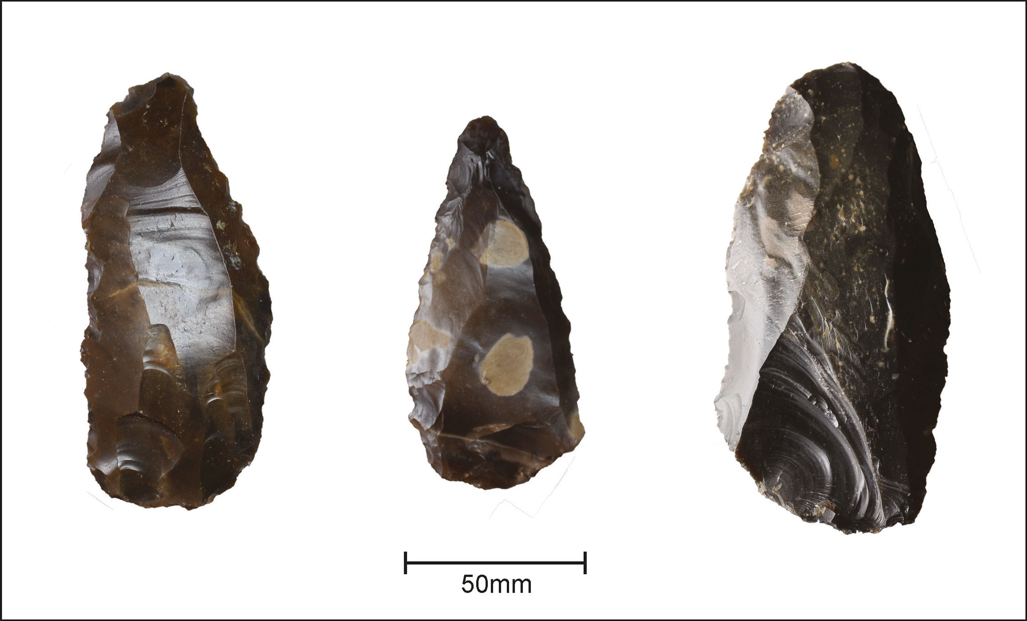
One of the key elements of these nourishment schemes is that they are, by their nature, public and highly visible; the aggregates are spread out over a large area open for people to ‘beach-walk’. As a result, after the newly formed beach at Clacton re-opened, a community of collectors—subsequently a vital part of this project—began to find large numbers of stone tools and mineralised mammalian remains.
Importantly, a significant component of the stone tools are ‘Levallois’, a flint-knapping technology that (in Britain) is associated with the Neanderthals.
This technology emerged around 300,000 years ago and persisted until around 200,000 years ago: it is a relatively poorly represented period.
The archaeology
Levallois technology is interesting not only because it is specific to a particular period, but also for what it implies behaviourally. It has been argued that it reflects increased levels of forward planning and mobility; a different way of perceiving and using the landscape based on the way the raw material is extracted, exploited, transported and discarded.
The tools from Area 447 are likely to reflect relatively expedient activity, inferred from the way they have been made, and the relatively fresh condition is also a clue to their depositional environment: this was not a high-energy setting (ie not involving fast-moving, agitated water courses) but something along the lines of a floodplain, where the stone tools experienced little movement after being discarded. A relatively small number of handaxes and non-Levallois stone tools exhibit more abrasion, indicating they are from different deposits and, probably, different time periods.
The species of fauna recovered from the beach are indicative of a cool, open environment dominated by woolly rhino, mammoth, horse and deer. Mammoth molars appear to be from the last glacial period (after about 115,000 years ago), but some of the horse remains are indicative of larger specimens, found from around 270,000–200,000 years ago. As with the stone tools, that the bones are not all from one period is supported by differences in their condition.
While we therefore appear to have a low-energy location yielding the Levallois material, the wider area that has been dredged comprises deposits from a range of environment types and ages.
How can we understand where this came from?
The significance of this archaeology made its re-contextualisation a priority: could we use aggregate company data to understand its original location, depositional environment and age? The data comprised geophysical data (multibeam bathymetry and sub-bottom profiler - techniques that measure the depth and shape of submerged terrain), complemented by track plots from the dredge head (so we knew where it had been) and logs from sediment coring, with some cores physically available.
From the sub-bottom it appears that the main area of dredging targeted a thin veneer of deposit overlying bedrock (London Clay) cut by a large palaeochannel (an ancient river system) dated by previous work to about 116,000 years ago (see diagram below) The veneer of sands and gravels must therefore be older than that date, fitting current timeframes for Levallois in Britain.
Where within this dredged area, though, did the Levallois archaeology come from? The multibeam datasets showed us where the majority of the seabed had been lost through dredging. Combined with a density analysis of the dredge-head plots, which showed where most dredging had occurred, this pointed to a specific ‘zone’ from which the majority of sands and gravels had been extracted.
Assessment of the sediment core logs showed only a handful that contained what looked like low-energy deposits that could have yielded artefacts in a fresh condition. One of these cores–VC23–was chosen for analysis based on its fine-grained, well-preserved, thick sequence. Significantly, VC23 also sits within the high potential ‘zone’ identified through the geophysics, and is, as such, a best guess of where the Levallois artefacts originated.
What were the environments like?
Sedimentary and palaeoenvironmental evidence shows that the area represented by VC23 was estuarine with brackish saltmarsh and a mosaic of habitats nearby, from beaches, dunes and floodplains to woodland and marsh; a varied and resource-rich environment. The species present point to a stage late in an interglacial, as the climate was starting to cool.
Importantly, despite the sediment cores being split and stored for five years before sampling, paired mineral luminescence dating was successfully carried out, providing dates of around 200,000, which confirmed this was a period when sea levels were dropping, landscapes emerging and temperatures cooling.
Archaeological implications and strategy
The dating is significant for two reasons. First, it places the archaeology at a time just before Neanderthals abandoned Britain for nearly 150,000 years. Second, it is comparable with the reassessed dates of Area 240, another Neanderthal site from the North Sea.
Are these sites offering glimpses into the gradual movement of Neanderthals into newly exposed landscapes and towards warmer climates?
These sites also highlight the sensitivity of submerged landscapes to commercial exploitation: the archaeology reported here was found because it was spread across a public space, while Area 240 was found due to a different serendipitous set of circumstances. How much of the record is being otherwise missed? With the increasing exploitation of the seabed, particularly as we move towards Net Zero, and the difficulties of working with a fragmented, ephemeral record at a landscape scale, this is a reasonable concern.
The submerged prehistoric record is challenging to work with, but proposals emerging from this work offer ways to improve our chances of success, alongside adherence to current guidance on best practice. Recommendations include the proactive development of geotechnical sampling strategies for areas of dredging, and engagement with local collectors prior to beach nourishment. This would allow regular beach-walking of newly emplaced sands, with mobile phone GPS records facilitating linking beach areas back to specific points on the seabed. Following current guidance this could then define exclusion zones while archaeological potential is assessed.
Conclusions
The way we work with submerged landscapes has seen huge progress in recent years, largely driven by evidence for the preservation of a record stretching back into Pleistocene time.
However, we are acutely aware of the increasing threat to these landscapes and of the nascent nature of our methods for investigating and protecting them.
The location of fragmentary but landscape-scale archaeology cannot be easily predicted, so a combination of proactive and reactive approaches, closer ties with industry, and a flexible outlook to amending methods is key to developing effective mitigation and harnessing the latent potential of these landscapes to tell the story of our hominin ancestors.

Further information
-
‘Strategic Support for Marine Development Management: Palaeolithic archaeology and landscape reconstruction offshore'
Bynoe R; Grant MJ, Justin; Dix JK, 2022: Historic England Research Reports Series 90/2022.
Download in PDF Format
You can download this article along with the others in this issue as a PDF magazine.


