Baseball and Bombers: USAAF Reconnaissance Photography During the Second World War
The United States Army Air Forces (USAAF) reconnaissance aircraft flew hundreds of sorties over England during the Second World War. The Historic England Archive holds a USAAF collection of over 20,000 photographs that records airfields, military bases, towns, and countryside in England between 1943 and 1944.
What is the USAAF Collection?
The Historic England Archive’s USAAF Collection comprises over 20,000 photographic prints taken by USAAF photographic reconnaissance (PR) aircraft during the Second World War. Nearly 19,000 frames have been catalogued.
Most of the photographs are vertical aerial photographs measuring 8 x 7 inches, 9 x 9 inches and 18 x 9 inches. Additionally, over 400 oblique 9 x 9-inch aerial photographs have been catalogued.
The photographs are a part of the Archive’s M Series Collection, including thousands of aerial photographs taken by the Royal Air Force (RAF) between 1938 and 1945. The ‘M’ stands for M section at the Allied Central Interpretation Unit, which was based at RAF Medmenham in Buckinghamshire. The section was responsible for photographic coverage of the United Kingdom. A selection of RAF photographs can be viewed via our Aerial Photo Explorer map.
Explore the USAAF Collection sites map
Our interactive map features over 3,600 photographs from the USAAF Collection. Click on the footprints to see a pop-up about it. You can click on the image to explore the photograph in more detail. Our USAAF layer can also be viewed on our Aerial Photo Explorer map.
What can I see in the photographs?
Many of the photographs in the collection show areas of the English countryside that include military sites amongst patchworks of fields. There are views of villages and towns, with coverage extending from Cornwall to the Wash, and from the Sussex coast to urban Lancashire.

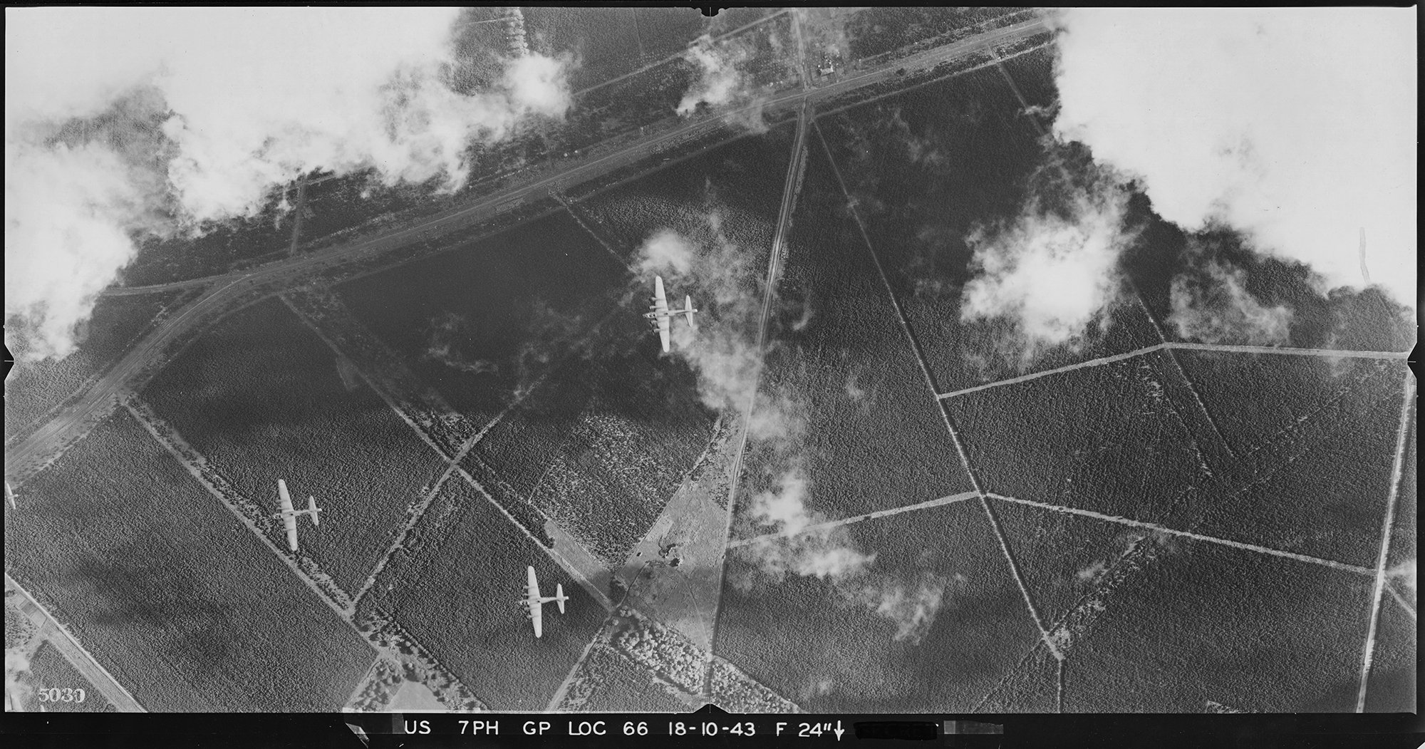
By zooming in on the photographs, some fascinating details can be found. You can see warplanes flying beneath the PR aircraft or parked on airfields. PR aircraft flying close to the ground even capture personnel playing baseball at a military camp.
Group (003 to 005)
Please click on the gallery images to enlarge.


The photographs also show incidental details, including Second World War anti-invasion defences. Traces of earlier times can also be seen, from prehistoric archaeological features to the remains of First World War camps. Others record busy townscapes or the relative tranquillity of the natural landscape and cloud formations.
Airfields
Over 200 airfields were occupied or newly built by the USAAF’s Eighth and Ninth Air Forces during the Second World War. Unsurprisingly, a host of these airfields feature in the USAAF photographs.
Airfield gallery (006 to 009)
Please click on the gallery images to enlarge.
, Northamptonshire, 9 May 1944. Hollywood actor and Eighth Air Force officer Clark Gable was stationed here in 1943. Gable flew several combat missions whilst making the documentary film ‘Combat America’. Source: Historic England Archive. USAAF Photography, US_7GR_LOC334_V_5017.")
, Cambridgeshire, 31 May 1944. B-17s of the 91st Bomb Group, the ‘Ragged Irregulars’, arrived here in October 1942. The famous ‘Memphis Belle’ was stationed at Bassingbourn. The bomber inspired the documentary film ‘The Memphis Belle: A Story of a Flying Fortress’ (1944) and the eponymous 1990 movie. It was the third USAAF heavy bomber to complete 25 missions over Europe. Source: Historic England Archive. USAAF Photography. Reference: US_7GR_LOC356_V_5040.")
 system was used. Pipelines along the sides of the runway carried fuel which were lit when fog obscured the airfield. The heat warmed the air and evaporated the fog, allowing pilots to see where to land. Source: Historic England Archive. USAAF Photography, US_7PH_GP_LOC161_V_5018.")

Military camps and storage facilities
As preparations for the invasion of Europe gathered pace, thousands of camps, storage facilities and hospitals were built on the edges of towns, on farmland and in the countryside. Many of these were photographed by USAAF PR aircraft.
Military camp gallery (010 to 013)
Please click on the gallery images to enlarge.
, Berkshire, 2 December 1943. During the Second World War, Newbury Racecourse was used as a marshalling yard for military equipment. USAAF transport aircraft based at Greenham Common carried paratroopers and towed gliders for Operations Overlord and Market Garden. Nearby Crookham Common was used to assemble gliders. These were towed from Greenham Common to other airfields. Source: Historic England Archive. USAAF Photography, US_7PH_GP_LOC90_V_5017.")


Military defences
Britain faced attack from German aircraft, flying bombs and rockets from October 1939 until March 1945. Early warning radar stations were set up to provide warning of Luftwaffe attacks and to track V1 and V2 ‘Vengeance’ weapons. Anti-aircraft batteries were built in strategic locations to engage enemy bombers attacking urban areas and military installations. USAAF PR sorties captured some of these sites on film.
Military defences gallery (014 to 017)
Please click on the gallery images to enlarge.


 Anti-Aircraft Brigade, established to defend the East Midlands from air attack. The surrounding fields show lines of ridge and furrow, a system of ploughing used from the Middle Ages. Source: Historic England Archive. USAAF Photography, US_7PH_GP_LOC130_V_5027.")

Towns and cities
The USAAF PR aircraft used cameras with a variety of lenses with different focal lengths. This meant that they could capture whole towns or great swathes of cities in single frames, as well as target more specific sites.
Towns and cities gallery (018 to 021)
Please click on the gallery images to enlarge.


Archaeology and ancient monuments
Whilst USAAF PR sorties do not appear to have deliberately set out to target ancient monuments and archaeological features, many of the photographs in the collection include details of various historic sites and landscapes.
Archaeology and ancient monuments gallery (022 to 025)
Please click on the gallery images to enlarge.


What were the USAAF doing in England in the Second World War?
To defeat Nazi Germany, the USAAF and RAF adopted a strategy to destroy enemy infrastructure by bombing targets from the air. Britain’s proximity to occupied Europe made it an ideal base for operations.
Even before the United States had entered the war, sites for USAAF bases in England were identified. The first aircrews of the USAAF’s VIII Bomber Command (later the Eighth Air Force) arrived in Britain in early 1942. It launched its first raid on Europe on 4 July, and regular missions were flown from August 1942. By the end of the war, it had undertaken over 440,000 bomber sorties against targets in Nazi-occupied Europe and Germany.
Who took the photographs?
For the USAAF’s strategic bombing of Nazi Europe to be effective, intelligence on targets was needed. Aerial reconnaissance units were created to photograph sites in occupied countries and Germany. These photographs and their interpretation would provide much of the necessary intelligence.
…no modern military force has achieved effective preparedness, much less success in the field, without adequate, timely intelligence.
The USAAF established PR units at airfields in England. Many of the photographs in the collection were taken by aircraft of two PR Groups, the Eighth Air Force’s 7th PR Group and the Ninth Air Force’s 10th PR Group.
Each Group comprised several squadrons, supported by specialist crews that maintained aircraft and cameras, processed films, printed photographs and interpreted the results. Written details on the photographs in the collection indicate which group or squadron took the photographs.
RAF Mount Farm in Oxfordshire was the principal airbase for USAAF PR. It was assigned to the USAAF and designated USAAF Station 234. By the end of 1943, four PR squadrons were based there, forming part of the 7th Photographic Reconnaissance Group.
Mount Farm was a satellite airfield for the RAF Photographic Reconnaissance Unit at nearby RAF Benson. It was also close to RAF Medmenham, the home of the Central Interpretation Unit, and the Eighth Air Force headquarters at High Wycombe.
The 7th PR Group took over 3 million photographs during an estimated 5,693 operational sorties during the war (other sources state 4,247). Notable missions included photographing invasion beaches ahead of D-Day. Twenty-nine sorties were flown on D-Day itself, recording the invasion beaches, and targets inland to monitor supply routes and troop movements.
After D-Day, the Group’s missions provided valuable information for the Normandy campaign, Operation Market Garden, the Battle of the Bulge, and the location and identification of enemy rocket launch sites. The Group also undertook a survey of military installations in the UK.
Why were the photographs taken?
When the various photographic reconnaissance squadrons arrived at bases in England, the crews had to learn British radio procedures and flying regulations. New pilots who joined the PR squadrons undertook flights over local areas to gain the necessary experience before qualifying for operational sorties. Locations such as airfields and construction sites were targeted for photo reconnaissance practice.
Training flights from Mount Farm included sorties to the south coast to acquaint pilots with checkpoints and the surrounding terrain. Flights were also made to test new and repaired aircraft and camera equipment. The 10th PR Group’s 31st PR Squadron also photographed sites in England for the Air Ministry. These were to aid the study of defence installations.
When there was poor weather over enemy territory, PR pilots often flew around the country to collect spare parts or to deliver documents, maps and photographs to other units. This courier service was extended to destinations in Europe following D-Day.
Pilots practised taking photographs at high and low altitudes, and ‘rat-racing’ exercises that rehearsed combat manoeuvres used when encountering enemy fighters.
How were the photographs taken?
A variety of aeroplane types were used for reconnaissance by the USAAF during the Second World War. Several of them can be seen in the USAAF collection photographs.
PR aircraft gallery (031 to 034)
Please click on the gallery images to enlarge.
, 30 April 1944. Parked near farm buildings is what is likely to be an F-9, the PR version of the B-17 bomber, belonging to the 7th PR Group. Source: Historic England Archive. USAAF Photography, US_27_LOC325_PO_0074.")
, 11 May 1944. Five days after this photograph was taken, an F-5 of 27th Squadron suffered engine failure and crashed into the kitchen of Mrs Frankie in the Norbury area of south London. Source: Historic England Archive. USAAF Photography, US_7PH_GP_LOC215_PORT_13085.")
, 11 March 1944. Source: Historic England Archive. USAAF Photography, US_7PH_GP_LOC215_PORT_13136.")

Early in the war, the RAF realised that fast, high-flying aircraft were better suited to photo reconnaissance than slower, larger aircraft. The USAAF followed the RAF’s lead and modified existing fighter aircraft. Some had their weapons removed to make room for cameras and additional fuel tanks so that long-range reconnaissance missions could be made over enemy territory. USAAF PR aircraft were given numbers with an ‘F’ for ‘foto’ prefix.
The first USAAF reconnaissance aircraft to arrive in England were adapted Boeing B-17 Flying Fortress bombers (F-9). Due to their vulnerability, the USAAF turned to adapting fighter aircraft, such as the Lockheed P-38 Lightning (F-4 and F-5) and the North American P-51 Mustang (F-6) for much of its PR needs. Some USAAF units also used British-made Supermarine Spitfires and de Havilland Mosquitos.
Spitfire 944
On 12 September 1944, Lieutenant John Blyth flew into RAF Mount Farm in a 14th Squadron Spitfire PR XI. He had just undertaken a mapping mission over central Germany. Unable to lower his landing gear, Blyth had to make a crash landing.
This 2005 film records filmmaker William Lorton interviewing Blyth, who recalls his experiences as a photographic reconnaissance pilot.
Blyth is shown viewing footage of his crash landing for the first time. The footage was filmed by Lorton’s great uncle, James Savage, who was serving as a flight surgeon at Mount Farm at the time.
Advances in camera technology meant that aircrew no longer had to lean out of cockpits to take photographs with hand-held cameras. The aircraft used by the USAAF PR squadrons had fixed cameras with magazines of rolls of plastic film capable of taking scores of frames. The pilot operated these with a push-button control.
The cameras were fitted with various lenses and positioned to take either oblique or vertical photographs. Oblique photographs were useful for capturing specific targets, particularly at low level. Vertical photographs could be overlapped and viewed through stereoscopes to give a three-dimensional view of buildings and landscapes.
The value of photographic reconnaissance
On the eve of the Second World War, the former chief of the German army, Colonel General Werner von Fritsch, stated that the organisation with the most efficient photographic reconnaissance would win the war.
During the Second World War, the USAAF’s reconnaissance squadrons undertook a variety of mission types, including strategic reconnaissance and tactical reconnaissance.
Strategic reconnaissance gathered information about targets for bombing missions and recording bomb damage. It also mapped enemy territory, located installations and recorded changes to them. On 18 April 1944, five F-5s from 10th PR Group’s 30th Squadron mapped three-quarters of Holland from 30,000 feet in under an hour.
Tactical reconnaissance gathered information for immediate use on the battlefield. This was especially valuable during and following D-Day. Sorties recorded and relayed information on enemy troop positions and movements, and planned and directed artillery fire.
PR squadrons were assigned numbered jobs, and each sortie flown could include one or more jobs. For example, one job could be an airfield, and another a harbour or a stretch of coastline or railway. If a target couldn’t be photographed due to cloud cover, the pilot might record something not on the job list. This was known as a target of opportunity.
When over a specific target, the pilot would often make several runs to try to get the best results. This was obviously a dangerous tactic, as enemy anti-aircraft batteries could anticipate the height and direction of their target. It also gave time for fighter aircraft to intercept. PR aircraft tactics included changing altitude and speed to confuse the enemy anti-aircraft gunners. To evade enemy fighters, PR aircraft would do their best to outrun their opponents. Some PR missions were accompanied by escort fighters for protection.
Whilst our collection of USAAF wartime photographs does not include images from combat sorties over enemy territory, they were taken by the pilots and aircraft of the squadrons that provided intelligence for the eventual defeat of Nazi Germany. This came at quite a cost. The 7th PR Group alone lost 62 pilots killed in action or the line of duty, including in accidents over England.
-
Aerial Photo Explorer
Explore England's changing landscapes through historic aerial photography, showcasing the growth and transformations of urban and rural areas.
-
Historic Military Aviation Sites: Conservation Guidance
This guidance is intended to promote the appreciation of historic military airfields and their associated buildings, so that their significance is pro
-
The Story of the US Army Air Forces in Britain During the Second World War
By 1944, over half a million USAAF servicemen were stationed in Britain. Find out more about their story on the Historic England Blog.
-
National Collection of Aerial Photography (NCAP)
The National Collection of Aerial Photography is one of the largest collections of aerial imagery in the world.
Sources
- Delve, K, 2006. 'The Military Airfields of Britain. South-Western England: Channel Islands, Cornwall, Devon, Dorset, Gloucestershire, Somerset, Wiltshire'. Marlborough: Crowood Press
- Delve, K, 2007. 'The Military Airfields of Britain. Northern Home Counties: Bedfordshire, Berkshire, Buckinghamshire, Essex, Hertfordshire, London, Middlesex, Oxfordshire'. Marlborough: Crowood Press
- Freeman, RA, 1986. 'Airfields of the Eighth Then and Now'. London: Battle of Britain Prints International Ltd
- Freeman, RA. 'UK Airfields of the Ninth: Then and Now, London: Battle of Britain'. Prints International Ltd
- Heiman, G, 1972. 'Aerial Photography: The Story of Aerial Mapping and Reconnaissance'. New York: The Macmillan Company, London: Collier-Macmillan Ltd
- Ivie, TG, 1981. 'Aerial Reconnaissance: The 10th Photo Recon Group in World War II'. Fallbrook: Aero Publishers, Inc.
- Keen, FS, 1996. '“Eyes of the Eighth”: A Story of the 7th Photographic Reconnaissance Group 1942-1945'. Sun City: CAVU Publishers, LCC
- Powys-Lybbe, U, 1983. 'The Eye of Intelligence'. London: William Kimber
- Price, Dr A, 2003. 'Targeting the Reich'. London: Greenhill Books
- Stanley II, Col RM, 1982. 'World War II Photo Intelligence'. London: Sidgwick & Jackson


