Explore our research reports with this map which is an on-going project that allows access to the majority of research reports produced for place-based projects. It covers most types of non-invasive surveys, including scientific analysis, such as tree ring dating and archaeobotany.
Research Reports Roundup August 2023
A roundup of new additions to the Historic England Research Reports database between June and August 2023, arranged by heritage theme.
New reports by theme
Open the sections below to explore the reports by each heritage theme.
Heritage science and dating reports
'Church of St Lawrence, Moat Lane, Towcester, Northamptonshire: Tree-ring Dating of Oak Timbers in the West Tower'
Authors: Dr Martin Bridge, Cathy Tyers
Four large beams supporting the ceiling to the ringing chamber were sampled. Only one was dated, giving a likely felling date range of AD 1468–1501. This may suggest that the tower was constructed in this period.
Read the report on the Church of St Lawrence
'6-8 Silver Street, Wakefield, West Yorkshire: Tree-ring Dating of Oak Timbers'
Authors: Alison Arnold, Robert Howard, Cathy Tyers
Dendrochronological analysis on samples taken from timbers of this building resulting in the successful dating of eight of them. A wall plate is dated as being felled in the range of AD 1543–68, with a ceiling beam and a king post being a little later, dating to AD 1587–91 and AD 1584–1609, respectively. The other dated timbers are also thought likely to date to the 16th century/early-17th century.
Read the report on 6-8 Silver Street.
'10 Church Street (Jennings Carpets), Tewkesbury, Gloucestershire: Tree-ring Analysis of Oak Timbers'
Authors: Alison Arnold, Robert Howard, Cathy Tyers
Interpretation of the sapwood on the dated samples would indicate that the timbers to the southern bay are derived from trees felled in AD 1467. The timbers used in the central bay were felled at some point during the AD 1450s–60s, possibly slightly earlier than those in the southern bay.
Read the report on 10 Church Street
'Priests’ Room & Annex, Church of St Mary, North Bar Within, Beverley, East Riding of Yorkshire: Radiocarbon wiggle-matching of oak timbers'
Authors: Alison Arnold, Robert Howard, Cathy Tyers, Michael Dee, Sanne Palstra, Peter Marshall
Independent validation of tentative tree-ring dating for a previously undated site chronology has been obtained by radiocarbon wiggle-matching and it can now be considered as a radiocarbon-supported dendrochronological date, that spans AD 1608–1731DR.
Read the report on the Priests' Room
'Monks Walk, 19 Highgate, Beverley, East Riding of Yorkshire: Radiocarbon Wiggle-Matching of Oak Timbers'
Authors: Alison Arnold, Robert Howard, Cathy Tyers, Silvia Bollhalder, Lukas Wacker, Peter Marshall.
Independent validation of tentative tree-ring dating for a previously undated site chronology. The three-bay front range to Monks Walk was therefore constructed in the early 14th century with significant rebuilding or repair work being undertaken to the building in the late 16th century.
Built heritage reports
'The Undercrofts of Westgate Street, Gloucester: Historic Buildings Assessment'
Authors: Rebecca Lane, Abigail Lloyd
This report examines the evidence for medieval undercrofts surviving on Westgate Street, Gloucester. For the purposes of this study undercrofts are defined as the stonevaulted spaces beneath a building or principal room. In Westgate Street there are three early and well-preserved undercrofts, which potentially date to the late 12th century.
Read the report on undercrofts
'Traditional Thatching Materials: Issues Affecting a Sustainable Future'
Author: Jenny Chesher
This report presents the results of research into the challenges facing indigenous producers of cereal straw and water reed for traditional thatching. It describes what the sector is already doing to overcome some of these problems and suggests further action to address other issues and help ensure a sustainable supply of thatching material in the future.
Archaeology reports
'Hinton St Mary Roman Villa, Dorset: Report on Geophysical Surveys, April 2023'
Authors: Megan Clements, Neil Linford, Paul Linford, Andy Payne
Earth Resistance and Ground Penetrating Radar (GPR) surveys were conducted as part of wider work to place the Hinton St Mary Roman Villa and mosaic into a greater landscape context.
Read the report on Hinton St. Mary Roman Villa
'St Stephen’s Beacon, St Stephen-in-Brannel, Cornwall: Report on Geophysical Surveys, March 2023'
Authors: Megan Clements, Neil Linford, Andy Payne
An Earth Resistance and Ground Penetrating Radar survey was conducted at St Stephen’s Beacon in the parish of St Stephen-in-Brannel, Cornwall as part of wider ongoing works to remove the beacon from the Heritage at Risk register.
Read the report on St Stephen's Beacon
'Castilly Henge, Luxulyan, Cornwall: Report on Geophysical Surveys, February 2022'
Authors: Neil Linford, Andy Payne
Ground Penetrating Radar magnetic and earth resistance surveys were conducted as part of a project to support ongoing work to remove the monument from the Heritage at Risk register. The survey revealed an arrangement of internal pits within the henge ditch, with a possible indication of recumbent stones.
Aerial survey reports
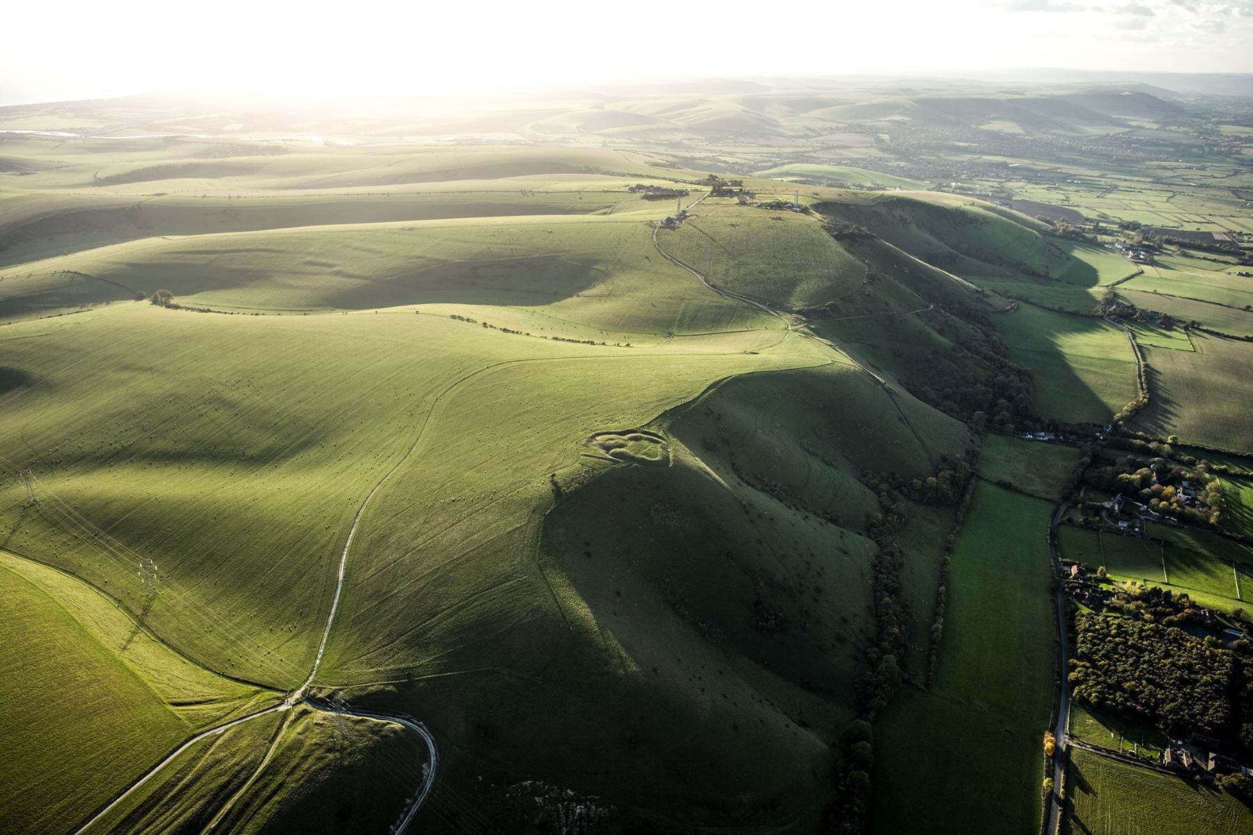
'Changing Chalk: Downs from Above. Aerial Survey of the South Downs north of Brighton'
Authors: E Carpenter, David Knight, F Small
The Downs from Above project is the aerial survey component of the National Trust-led and National Lottery Heritage Fund-supported Changing Chalk partnership. The project focussed on the area of the South Downs National Park to the north of Brighton and Hove. The archaeological remains identified from lidar and aerial photographs on the South Downs ranged in date from the Neolithic to the Cold War. The lidar was particularly valuable in showing the low earthworks that define extensive later prehistoric and Roman field systems across the Downs.
'Dartmoor and Upper Plym Valley. Aerial monitoring of scheduled monuments on the English Heritage Estate'
Authors: Katy Whitaker, Olaf Bayer
This project was designed to develop methods and provide baseline data to the English Heritage Trust to enable assessment of change over time. This work focussed on 4 guardianship sites on Dartmoor, Devon: Grimspound, Merrivale Prehistoric Settlement, Hound Tor Deserted Medieval Village and the Upper Plym Valley.
Find more reports

Download in PDF Format
You can download this article along with the others in this issue as a PDF magazine.


