The South Downs Explored From Above: A Landscape of Rich Archaeology Revealed
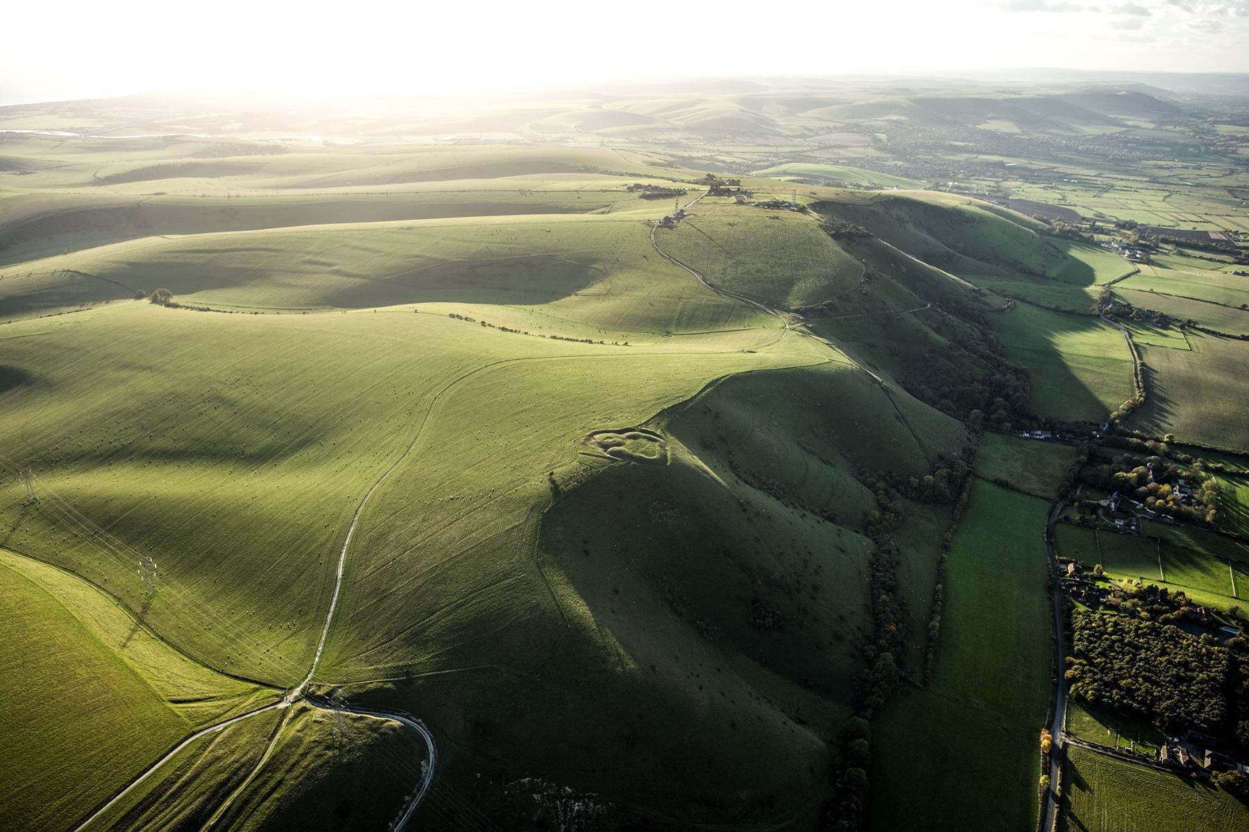
Historic England has used aerial imagery to map hundreds of archaeological sites dating from the Neolithic to the Second World War, across 192 square kilometres of the South Downs, to the north of Brighton.
A new report published today reveals the area's rich history and how our ancestors have shaped the landscape, as part of a wider National Trust-led project focused on the South Downs National Park.
An accompanying interactive map encourages people to discover and connect with this landscape and its remarkable past. People can add data to the map to report the current appearance or condition of earthworks and share personal histories or connections to a site.

From the echoes of Neolithic ceremonies to the upheaval of the Second World War, these archaeological sites contribute to the unique character of the South Downs. They have been brought together in our new interactive map using aerial sources and archive research. Highlighting sites with a tangible link to the past can connect people to their area and foster a sense of place. Our connection to the land continues to this day – around 117,000 people live and work within the National Park’s boundaries with many more visitors throughout the year.
Downs from Above
Downs from Above is one of 18 projects being delivered as part of the Changing Chalk partnership running for four years until April 2026. It aims to engage communities as active participants in discovering, interpreting and celebrating the cultural heritage of the Downs. The partnership is led by the National Trust, supported by a National Lottery Heritage Fund grant and funding from People’s Postcode Lottery.
Historic England’s aerial investigation team analysed more than 9,500 aerial photographs as well as recent airborne laser scans (lidar) – a technique that uses an aircraft-mounted laser to build a 3D digital elevation model of the ground below – to locate, identify and map marks in the landscape which represent the thousands of years of human activity the Downs have seen. The results cover various archaeological features ranging from small chalk pits to vast field systems.
Utilising aerial photos, both old and new, and lidar images from laser scans, the Downs from Above mapping can give us a unique way to understand our downs, and our heritage on them. Not only are new features being discovered, but the true character of existing features are being recognised for the first time. This new data is a great resource, both for amateurs and experts alike, to get onto the downland and really see what is just below their feet. We hope it will inspire a host of new projects in the area, allowing us to delve deeper into our shared past.
7 examples of human activity that have shaped the South Downs through history
Ancient burials
Ancient burial sites from the Neolithic (4,000 BC to 2,200 BC) onwards were marked by the creation of mounds called barrows. Barrows can be found dotted across the Downs, although most are sited along the northern ridge. These early cemeteries often developed over many centuries and, in some cases, acted as a focus for burials as late as the early medieval period (AD 410 to 1066).
At Western Brow, due south of Westmeston village, there is a collection of ancient barrows which can clearly be seen from above to be of different size and shapes. Bronze Age (2,600 BC to 700 BC) barrows tend to be larger and clustered in groups, while early medieval barrows are generally smaller. The mounds on the east of the group at Western Brow are smaller and delineated by ring ditches: these are considered early medieval, while the larger mounds are likely to have Bronze Age origins. The site is protected as a scheduled monument.
Farming: Dewponds for sheep
Historically, sheep had a prominent place in farming not just for the wool and meat they provided but also for their role in manuring the arable fields, a system known as sheep and corn farming. Physical evidence of sheep faming exists across the South Downs in the form of dewponds and livestock enclosures.
Dewponds are man-made drinking pools for animals, and are situated across the South Downs on ridges, hilltops and within combes.
Leisure: Devil’s Dyke and all the fun of the fair
Devil’s Dyke and its commanding viewpoint has been attracting people for millennia. The location of a defensive hillfort in the Iron Age, by the Victorian era it drew crowds of tourists.
The expansion of the railway in the mid-19th century opened up many places to the wider public, including Sussex. The countryside and coast near Brighton became a place of refuge and recuperation for the middle classes as the health and recreational value of the seaside was recognised. The first holiday destinations were born, and activities and attractions were developed to amuse those with money and time on their hands.
In its heyday, Devil’s Dyke boasted among its attractions: two bandstands, lawns, tea pavilions, a 7-ton replica Naval gun and even a zoo. The Dyke Hotel, built around 1831, and the surrounding ridge was home to an adventure park with fairground attractions occupying much of the interior of Devil's Dyke hillfort. There were a series of fairground adventure rides, including a rollercoaster and an aerial ropeway where thrill-seekers traversed the Devil’s Dyke in a metal cage suspended from a wire strung between two metal pylons on either side of the valley. Shadows of these attractions can be seen on the lidar images.
Second World War: Shoreham training camp and agriculture
One day in September 1914, thousands of troops arrived into Shoreham Station, much to the shock of the local residents. Bad weather meant many soldiers were billeted in local houses overnight until a vast tented encampment was established in Buckingham Park and Oxen Fields. Thousands more men arrived over the following days and the construction of a hutted camp began in earnest on Slonk Hill. The remains of the First World War training camp at Shoreham survived as earthworks into the 1940s and are recorded on Second World War RAF aerial photographs.
Following the outbreak of the Second World War, the growing military presence on the Downs led to roads being closed and farms evacuated. The chalk upland eventually became a training ground and staging post for the D-Day invasions in 1944. The Downs were slowly opening back up to the public before the end of the war as the threat of invasion lessened. By 1947, with rationing ongoing, many areas of traditional grass downland were converted to arable fields to provide food for the nation.
Routes and tracks: the movement of people
The traces of many tracks, hollow ways and paths cross both the Weald and the Downs. These represent fragments of a complex network of routeways from many periods which are remnants of historic human (and stock) movement through this area.
A feature of the northern face of the South Downs and the opposing south face of the North Downs are deeply incised tracks and paths. In this part of the country, they are known as ‘Bostalls’: a Sussex name for incised routes, probably drove ways, which lead up the steep northern scarp of the South Downs from the Weald onto the open Downs. These were used to move sheep and other livestock to and from pastures to market, and routes to the coastal region.
Industry: chalk pits
Historically Sussex is known for an abundance of raw materials that fed many industries. In the medieval period the Weald became a centre for ironworking and glassmaking and later for brick and tile making. Chalk extraction and lime burning have also left their mark on the landscape.
Offham, to the north of Lewes, operated a large chalk pit from 1809 to 1890. At its peak of production, Offham Chalk Pit had four lime kilns, which processed the chalk into lime which was transported away by river.
Settlements and agriculture
The location of early settlements and land farmed by our ancestors can be seen as cropmarks and earthworks across the Downs. Soil accumulated along the field boundaries during ploughing leaves raised banks known as lynchets. Later prehistoric or Roman lynchets, such as those on Balmer Down, survive up to 3 metres high but many others have been almost completely levelled. Many of these earthworks may be difficult to see on the ground but can be more easily identified on lidar images.


