Aerial Reconnaissance and Archaeology
Aerial reconnaissance is a very effective method of discovering and recording archaeological sites and involves archaeologists flying in a light aircraft, searching for, and photographing archaeological sites and landscapes.
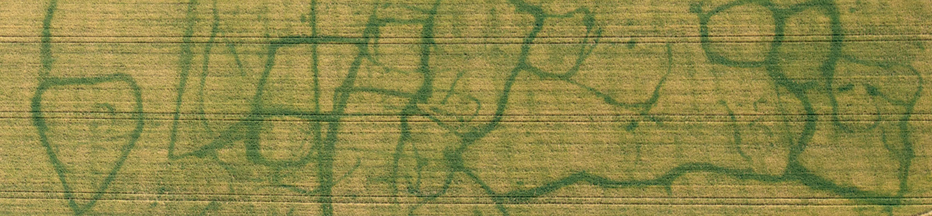
While looking for archaeological sites in the form of cropmarks, soilmarks and earthworks, known sites are recorded to monitor their condition as are buildings and historic landscapes.
All the aerial photographs taken by or funded by Historic England are stored in our archive.

Discovery
Aerial reconnaissance involves an archaeologist flying in a light aircraft searching for and recording historic sites and landscapes. The geographical scope of observer-led reconnaissance is national, but is targeted to meet specific priorities and allow the flexibility to respond to seasonal weather conditions.
New sites are discovered in the form of cropmarks, soilmarks and occasionally earthworks.
The archaeologist carries a digital camera and a map with plots of known archaeological sites, including scheduled monuments, registered parks and garden, plus project specific targets.
Once a decision is made to take a photograph, the archaeologist directs the pilot to position the aircraft to get the best view of the site. The ideal angle will depend on what the photograph will be used for, including mapping, monitoring or illustration.
Observer-led reconnaissance is a very effective way of discovering new sites and is a major contributor to Historic England’s aim of discovering England’s hidden heritage.
We do this by coordinating a national program of aerial reconnaissance with a mix of our own staff and local fliers funded via Heritage Protection Commissions (HPC).
Monitoring protected sites
An important aspect of the reconnaissance programme is the recording of scheduled monuments to assist colleagues in Historic England’s regional teams with monitoring the condition of protected monuments.
Aerial photographs taken at different periods can demonstrate how a site's condition can change over time. Common issues affecting scheduled monuments include animal burrowing, scrub growth, plough damage and vehicle damage.
Historic landscapes
Aerial photographs are also used to record and illustrate aspects of the historic environment showing how past human activity has shaped the landscape that we live in today.
Working with other experts in Historic England the reconnaissance teams contribute to a variety of projects from recording 20th century tower blocks to prehistoric field systems. The images are used in a variety of publications that inform and give guidance on how to protect the past.
Archaeological Investigation
-
Email
[email protected]
-
Address
EC4R 2YA


