Hydraulic Fracturing (Fracking) and the Historic Environment
High pressure, hydraulic fracturing (also known as fracking) is a new technology to the UK and it operates within a complex regulatory framework. This web page includes basic information about hydraulic fracturing. It also poses some questions that help decision makers in the planning process consider the potential impact of a proposal.
Hydraulic fracturing is a technique used to extract gas (or oil) from rock by injecting water at high pressure. Reference is commonly made to ‘shale gas’, which means a natural gas (predominantly methane) found in shale rock. Hydraulic fracturing is one of the techniques used in unconventional oil and gas development to extract shale gas. ‘Unconventional’ is a reference to the rock resource, which would not be targeted through conventional drilling.
For an introduction to hydraulic fracturing (“fracking”) there’s a YouTube video available, originally posted by the Department of Energy and Climate Change (DECC) and then reloaded by the Department for Business, Energy and Industrial Strategy (BEIS) in 2016. There’s also a recent parliamentary briefing on ‘Shale Gas and Fracking’.
The different phases of shale gas development
The National Planning Policy Framework (NPPF) states (when referring to onshore oil and gas development) that minerals planning authorities should clearly distinguish between the three phases of: exploration; appraisal; and production. However, exploration and appraisal can be continuous.

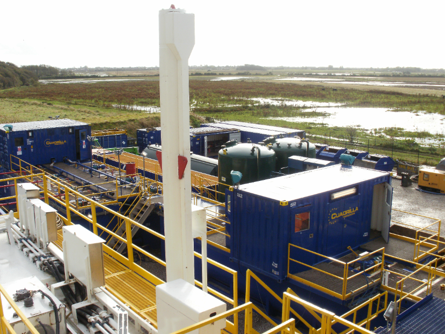
Exploration usually involves seismic surveys, exploratory drilling and, in the case of shale gas development, it can involve hydraulic fracturing. But this is not always the case. Exploration will usually require temporary structures at the surface. These require consent from local planning authorities the Environment Agency after assessment of the impact on landscape character and the setting of heritage assets. Typically operational activity at an exploration site spans two to four months. Usually impacts on setting are most significant at the exploration stage, due to the impact of the drill rig.
A typical shale production pad will use about 2 hectares of land. This provides enough space for all of the drilling rig equipment, piping and storage, and other site facilities such as mobile portacabins for offices and worker restrooms. Once drilling has been completed, activity on the surface will lessen greatly as wells start to produce natural gas. The production phase within a 10x10km licensed area is likely to entail multiple well pads.
In addition to activities directly linked with exploration and production, it is important also to consider what is entailed in monitoring activities associated with shale gas development.
Safeguards and site selection
Increasingly Minerals Plans across the country include one or more policies on shale gas development. Such policies may, for example, include reference to the siting of well sites and associated facilities in the least sensitive location from which the target reservoir can be accessed.
The presence and location of historic assets would typically inform site selection by the operator, who would use the NPPF and relevant policies in the local Minerals Plan to inform their decision. As a result, promoters need to be clear in site selection about potential impacts of development on designated and undesignated assets.
Checklist of questions to consider when reviewing potential impacts of shale gas development on the historic environment
Impacts from shale gas development on the historic environment include direct and indirect impacts, including (but not necessarily limited to) those summarised in the checklist below:
- Has the applicant taken into consideration designated and undesignated heritage assets in the location of the well pad? This should include appropriate reference to the Historic Environment Record (HER) and National Heritage List for England (NHLE).
- What steps are appropriate (if any) to mitigate the impacts of removal and/or compaction of soil on archaeological remains? Is a survey of archaeological remains needed?
- What are the impacts during exploration and production on the setting of heritage assets? Visual impacts are likely to be most significant during the exploration stage, though these are short-term. Bear in mind that the setting may also be impacted by noise, impacting the enjoyment / experience of a nearby designated heritage asset.
- What are the potential impacts of the developer’s suggested seismic and/or groundwater monitoring activities on the historic environment and what related mitigation may be appropriate? Is there adjacent similar development (e.g. quarrying) where monitoring activities are also undertaken and how might adjacent development and associated monitoring schemes relate to each other?
- How have the impacts from vibration been assessed in the heritage impact statement? Is monitoring of vibrations needed on designated heritage assets within the area impacted by drilling, hydraulic fracturing and/or surface-level equipment? Review the need for a buffer between heritage assets and the proposed development, including vibration impacts from HGVs / transport.
- If the area is likely to contain water logged archaeology, has this been considered by the applicant? (Generally speaking the impact of hydraulic fracturing on water resources will be at a depth below water-logged archaeology.)
- What are the cumulative impacts of development, for example alongside other oil and gas development in the area? And how will the industry demonstrate that they’ve addressed any pre-existing weakness caused by prior development e.g. existing fractures from coal mining?
- Do plans for site restoration during decommissioning appropriately take in to account proximity to the setting of heritage assets?


