Using Aerial Photographs
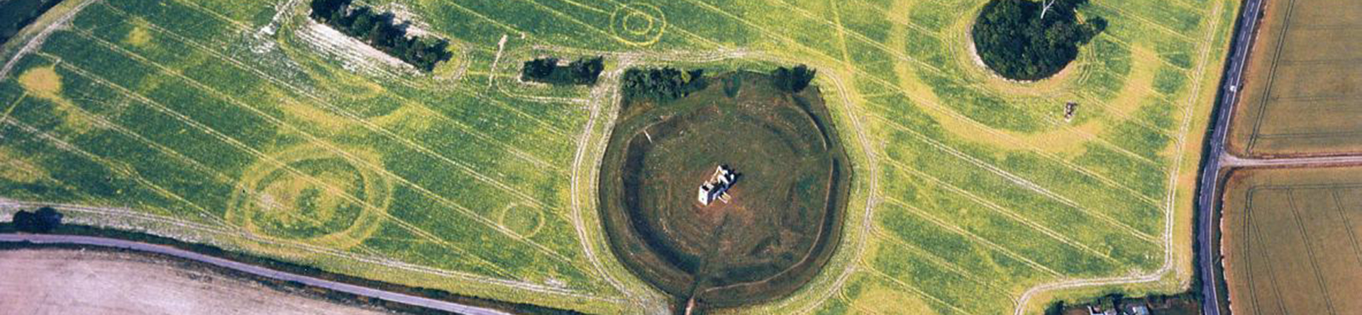
Archaeology has long benefited from the use of aerial photography, revealing sites that are often difficult or even impossible, to see on the ground.
Interpretation and mapping of sites visible as cropmarks, soilmarks and earthworks allows a better understanding of past landscapes to inform research and management strategies. New technologies such as lidar are adding to the toolkit of the aerial surveyor.

Aerial photographs and the historic environment
The key uses of aerial photographs for study of the historic environment include:
- Discovery
- Illustration of architectural and archaeological sites and landscapes
- Recording landscape change - in rural and urban contexts
- Archaeological mapping and landscape analysis
- Conservation and heritage management
Photo interpretation
Taking a structured approach to photo reading will enable you to better understand a site, or landscape, and avoid missing important details that can lead to mistaken interpretations.
First, look at ALL of the available aerial photographs. This can give you a view of the site from various angles, under different conditions and over a period of several years.
Earthwork sites, and cropmarks, can appear differently (or disappear) when viewed from different directions. Looking at a wide range of photographs (vertical and oblique photographs) from different years will give you a perspective on the changing landscape, condition and preservation of the sites over time.
Aerial photographs also contain many features that may mislead the unwary and make the archaeology difficult to see. Specialist staff interpret and map the archaeological information bringing together data from photographs taken over many decades.
Aerial survey projects may investigate individual sites and their immediate context or explore extensive landscapes creating archaeological maps which cover hundreds of square kilometres.
Types of aerial photograph
Oblique photographs are usually taken with a hand held camera through the open window of a plane. The photographs are taken at an “oblique” angle to the ground but vertical or near vertical shots are common.
A light aircraft can be easily manoeuvred and a number of views taken from different angles. This maximises the visibility of the archaeology and provides sufficient control to correlate the features on the photo with a map.
The wide geographical range and flexibility of using of the light aircraft means that oblique aerial photographs are usually high quality images taken in optimum conditions.
Vertical photographs are taken using one or more fixed cameras pointing straight down at the ground, usually within a modified plane. They fly on prescribed courses to provide blanket coverage of large areas.
These surveys were usually made for topographical mapping and so may not have been taken in ideal conditions for recording archaeological features.
The UK collection's mainly range in date from the 1940s and provide blanket cover at intervals but for more recent years there is less complete cover. Online sources usually provide up to date repeat cover.
The aerial photographs in the national, and some local, archives in England comprise those taken for non-archaeological purposes, usually vertical photographs, and those taken specifically to record archaeological sites, historic buildings and landscapes, usually oblique photographs.
Other sources include online image sets, such as the Britain from Above or the various layers on Google Earth. Finally, the increasing use of lidar in archaeological and non-archaeological contexts means that, as with other aerial sources, there is body of information in various formats available to archaeological researchers.
This includes what could now be considered ‘historic’ lidar data and visualisations that can be used for prospection but also form a benchmark of the condition of archaeological monuments or landscapes.
These sources span a date range from the 1920s through to the present. The large volume of sources in England and the long time range in particular are important aids to understanding how, and why, we see archaeological evidence but also provides information on the survival and likely preservation of remains.
Historic aerial photographs provide a fantastic record of landscape change through the 20th century. They record many unrecognised earthwork and cropmark sites because many collections have not been examined for archaeological purposes.
They also record sites, which have been ploughed level due to the expansion of arable in the post war period, or been lost to urban expansion and other developments.
The historic aerial photographs also provide an important contemporary or near-contemporary record of structures relating to the Second World War. These include military defensive structures, airfields, camps, hospitals, civil defence and training areas.
Archaeological Investigation
-
Email
[email protected]
-
Address
EC4R 2YA


