Discovering Coastal Heritage
This page outlines what Historic England and other agencies are doing to find out about and protect our vulnerable coastal heritage from:
- Erosion
- The rise in sea levels
- Development
- Agriculture and
- Neglect
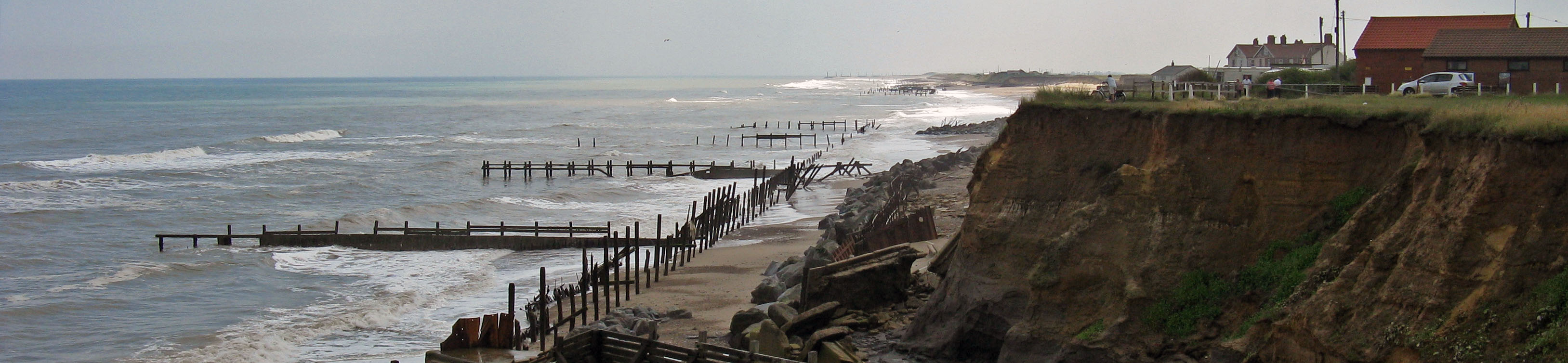
Threat and opportunity
Since the last glacial maximum circa 22,000 years ago and the melting of the vast ice sheets that covered the European and other landmasses, global sea levels have risen by some 110-130m.
That readjustment was largely complete by the beginning of the Neolithic period, circa 6,000 years ago, by which time the English Channel and North Sea had formed. Britain was no longer physically joined to Europe but had become an archipelago of islands lying off the continent’s north-west corner.
Since the Neolithic, sea levels have continued to rise more slowly, perhaps by no more than 2m, slowly inundating and eroding areas of the coast. Because of complex patterns of sediment movement this means that in places new land is also sometimes created, as has happened at Romney and Walland Marshes on the Kent/East Sussex border.
Climate change, however, means that both the rate of sea-level rise and scale of change to the coastline are now accelerating after a long period of relative stability.
According to the UK Climate Projections (UKCP09) website , sea levels rose by circa 0.2m in the last century, and are projected to rise by anything up to another 1-2m by 2100 – i.e. probably in excess of 1m in just 200 years.
At the same time a warming environment means that storms and storm surges are likely to become stronger, higher and more frequent.
Rising sea levels mean that flooding and erosion are set to increase along the coast, while ‘stormy winters’, such as that of 2013/14, may well become more commonplace leading to damage to historic seaside structures and greater localised erosion of undefended shorelines.

These threats are in addition to those that the historic environment faces everywhere from agriculture, development and neglect.
On the other hand, erosion can lead to the discovery of buried archaeological sites – even occasionally ones that have lain hidden for 900,000 years such as the human footprints and other cultural material on the beach at Happisburgh (pronounced Hayesborough) in Norfolk.
'Seahenge'
The Bronze Age timber circle, dubbed ‘Seahenge’, which had an upturned tree stump at its centre and was discovered on the beach at nearby Holme in 1999, is another recent example of a site unknown before erosion.
Dendrochronology (tree-ring dating) pinpointed the year the monument was erected to precisely 2049 BC. Why it was built and how it was used, however, are still hotly debated questions.
Such exposures present valuable opportunities to increase our understanding, but are often only exposed for very short periods before being re-covered, or else are rapidly lost to continuing erosion and have to be recorded quickly.
What is Historic England doing?
We need to ensure that we have identified historic assets and landscapes of all types and periods around England’s coast to devise appropriate responses for protecting the most significant features and places. We also need to monitor the coastline for new archaeological discoveries exposed by erosion.
We seek to identify and protect sites in two ways:
- Through a series of regional or sub-regional Rapid Coastal Zone Assessment Surveys (RCZASs ) that eventually will report on the entire English coast
- By carrying out or funding thematic projects that seek to increase understanding of particular sites or classes of site on the coast.
Protection has to be underpinned by information and understanding. The data obtained from the RCZAS programme and other projects help inform decision-makers (such as ourselves) to manage coastal heritage.
Responses may include designation (legal protection) of sites, physical protection (eg, building of sea defences), recording before loss (as at Happisburgh and Seahenge) or even in rare cases relocation of built structures further inland as happened to the Clavell Tower in Dorset.
The surveys and projects all provide information that helps determine the best approach, especially in relation to the national Flood and Coastal Erosion Risk Management (FCERM) strategy led by Defra and the Environment Agency.
RCZAS programme
The RCZAS programme is necessarily a point-in-time exercise, whereas as we have seen the coast is a dynamic landscape where change is continuous.
It is hoped that regular monitoring of the coast (for example, following storms) will be addressed by the Coastal and Inter-Tidal Zone Archaeological Network (CITiZAN) project, set up by Museum of London Archaeology (MOLA).
That project aims to train and enable an army of volunteer ‘citizans’ to monitor and record sites newly revealed or at risk of being destroyed by coastal erosion.
If you would like to know more about the project, or even become a ‘citizan’, please visit the CITiZAN website.
The project is supported financially by the Heritage Lottery Fund (HLF), the Crown Estate and the National Trust, and through advice and help-in-kind by Historic England.
Existing coastal settlements have a special character and atmosphere of their own. Historic England has a separate work programme, therefore, to understand and protect the significance of historic seaside settlements and port and harbour installations.
Because England’s coastline has changed and evolved over time as sea levels have risen, large areas of what was once dry land now lie beneath the waves, and Historic England also has research programmes to investigate, record and protect these submerged landscapes.
In addition England is a maritime nation with a long tradition of sea-faring. We also research this tradition by examining the evidence of shipwrecks and lost cargoes that lie scattered across the sea-bed within England’s territorial waters.
Marcus Jecock
Investigator Assessment Team (North)-
Email
[email protected]
-
Department
Investigation and Analysis, Research Group, Historic England, 37 Tanner Row, York YO1 6WP -
Address
EC4R 2YA
-
Phone number
01904 601928


